 |
||
 |
||
|
More than 3,400 years before a British highway sliced the
Stonehenge landscape
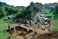
in half, some people cut a beautiful pit a metre deep into the chalk
with no tools except picks made of red deer antlers.
They may have had primitive tools, but there was nothing primitive about their skills: the bottom of the pit was so neatly levelled that you could balance a mug of mead on it without spilling a drop. As druids and tourists headed towards Stonehenge for the 22 December winter solstice, when the midwinter sun set framed perfectly by the giant stones, Historic England archaeologists were hard at work. A pit was discovered perfectly cut to support a huge wooden post. A neat trench links to a second equally impressive pit for another massive post - so large they would have been visible for miles. The line of the trench seems to lead on towards the neighbouring field, carefully zigzaggng to avoid an earlier long barrow. But what is it? Phil McMahon, Historic England archaeologist, and Nick Snashall, at the National Trust, have no idea. “This is keyhole surgery,” McMahon said. “We’re throwing up as many questions as we answer. |
||
 Stonehenge may have been first erected in Wales, evidence suggests |
. |
They
have surveyed with aerial photography, ground penetrating
radar, studying centuries of maps showing now-vanished
monuments, and excavating just yards from winter crops and pigs.
This to is
assess the effect of a tunnel to replace the present road. After decades of
argument, in which traffic has increased to the point that the road frequently becomes a
crowded car park, the replacement of the road by a tunnel to
the south of the present line has been included in the government’s
five-year road plan. Tourists very rarely cross the road – at busy times it is almost impossible – but thousands of monuments, recorded and still to be discovered, including round and long barrows, linear monuments, burial mounds and ring shaped banks which once surrounded ponds, lie among the fields and clumps of woodland. |
|
Many of the known sites have never been excavated, and the survey
has also revealed some new ones, including two burials spots which
may date from the iron age and a puzzling square enclosure which could be
prehistoric, Roman or medieval, almost on the shoulder of the road.
But the survey has demolished the claims of other sites. But it has also shown how
intensively the landscape was farmed for thousands of yearslong
before the
Romans arrived. Duncan Wilson, chief executive of Historic England, says, "The road was the great outstanding problem. There are still many questions to resolve about the details of the tunnel and where the portals should be sited, but I think the advantages of a tunnel far outweighs the disadvantages.” Every move the archaeologists make is watched by the Stonehenge Alliance – a group that includes local residents, landowners, historians, druids and the Campaign to Protect Rural England – who argue for a much longer tunnel with the entrance and exit placed well outside the world heritage site. The alliance believes that doing nothing about the road would be much better than doing the wrong thing. Kate Fielden, an archaeologist and member of the alliance, said: “The Stonehenge Alliance now has almost 20,000 signatures asking for no further damage to the world heritage site. “It is extraordinary that archaeological evaluation trenching should be taking place within the site before any final decision on tunnel length, engineering feasibility and costing have been investigated. Our bottom line is that there should be no further damage to the site.” McMahon and Snashall say the design of the tunnel, the portals and problem areas such as the link roads and the lighting of its approaches, must be “exemplary”. “We can’t just let the highway engineers reach for off-the-shelf solutions – but if we get this right there is a chance of doing something which finally rejoins the two halves of this amazing landscape, and which can also set the standard for other ancient sites across the world.” |
||